Here are the first images from the WorldView-3 public imaging satellite

Justin Kahn

Posts: 752   +6

images public high-res imaging satellite

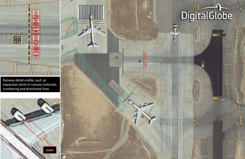
Earlier this month DigitalGlobe's WorldView-3 satellite successfully launched and now we are getting our first look at some of the images. As you can see in the images below its fairly easy to pick up on particular vehicles and landmarks.

The WorldView-3, is capable of taking images at double the resolution of Google Maps, according to the company, but is still limited by government restrictions. It has initially been snapping shots over Madrid that have been resampled down to 40 cm to meet the limitations. The satellite is capable of 30 cm images or better, which is drastically more detailed, but we will have to wait for restrictions to be lifted before we can catch a glimpse of them.

Either way, the 6200 pound, 18-foot tall satellite's images look fairly impressive so far. You can download the full resolution 40 cm images on the official DigitalGlobe site.

Due to DigitalGlobe being so firmly planted in the commercial satellite imaging space, it has managed to get the resolution restrictions lifted, but it won't be until February until that content becomes available to its clients. DigitalGlobe says the satellite images could help companies and even governments to monitor the progress of various city development projects among a wide range of other things.

Permalink to story.

 
Whoa... this is disgusting where is the Nudity tag & age restriction! This is highly detailed pornography we are dealing with, letting uneducated people seeing this would be against the law!

Those nude shots tho are nice! Can't wait to see more Hi-defenition xxx stuff like this, just downloaded those pictures into the Stank Bank ;D
 
Still doesn't hold a candle to military grade satellites (or so I've been told).
 
I was looking at a few residential construction sites in my region, at it was a total pornography - almost every one of them appeared tits-up.
 
Still doesn't hold a candle to military grade satellites (or so I've been told).

True... when my brother was in the Marines he was able to look down into our parents kitchen through their skylight. And we're worried about our emails being on some NSA server. Ha!
 
No matter what we taxpayers are footing the bill and should be allowed to access all these DGSAT with some restrictions. Google Maps uses DG but not enough to get a clear show if you zoom in. Bing Maps have a special Beta feature that can give you a very clear 3D zoom in effect.
 
I'd better stop storing my Playboy magazines next to my long drop... in fact I'd better stop using long drops altogether.
 
Anything that doesn't show from the birds view should be fine, like a sewage pipe.

P.S. You are welcome!

Yes, I have to stop walking around looking at the sky for shiny objects. I also keep getting bird poo on my face.
 
Back