Former Nicaraguan military commander Eden Pastora is blaming Google Maps for ordering his army to invade a portion of Costa Rica, according to Search Engine Land. The troops set up camp, took down a Costa Rican flag, raised the Nicaraguan flag, destroyed a protected forest, cleaned up a nearby river, and dumped the sediment in Costa Rican territory.
"Look at Google's satellite photo and there you can see the border," Pastora told La Nacion (Spanish translation), the largest newspaper in Costa Rica. "In the last 3,000 meters, the two sides (of the river) are Nicaraguan. Then from there to El Castillo, the border is the right riverbank, it's clear."
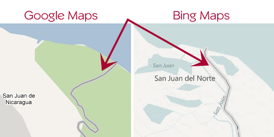
Apparently Google Maps isn't always right. The official maps used by both the Nicaraguan and Costa Rican governments show the border continuing on the right bank of the San Juan River all the way to the Gulf of Mexico. As you can see in the image above, Bing Maps shows the border more accurately. If Pastora is going to ignore the official maps and insists on using an online mapping service, maybe Costa Rica should tell him to just Bing it next time.