In brief: Friends and family can now view your smartphone's remaining battery life if you decide to share your location via Google Maps. The feature aims to eliminate stress and anxiety from a lack of response when batteries are running low.
Last year Google implemented a location sharing feature within Google Maps so that friends and family could keep track of one another. Now, the feature will also share your phone's battery status when location sharing is enabled.
Allowing others to view the state of charge can help alleviate concerns. Should someone's battery be running low and subsequently does not answer a phone call or text, it is likely that their battery died or they switched over to airplane mode to conserve their remaining battery life.
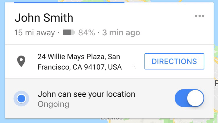
On the flip side, knowing that a friend or family member has plenty of battery life left and getting no response could raise red flags. Of course, some smartphone users are better than others at actually making use of their devices and responding to communication.
The battery level sharing feature was originally discovered in February in Google Maps beta version 9.71 by AndroidPolice. After several users reported seeing different variations of the feature, it is now being rolled out to all users. Both iOS and Android versions of Google Maps will eventually receive the update.
Even though it is a potentially useful feature, Google was not the innovator of this idea. Zenly, a social map app that Snapchat acquired had a battery sharing feature back in 2016.
Image Credit: Maps screenshot via TechCrunch
https://www.techspot.com/news/75799-google-maps-now-shares-battery-life-when-sharing.html