Google has made good on an initiative announced earlier this year to archive areas of Northeastern Japan that were affected by the earthquake and resulting tsunami in March. 360-degree imagery of devastated areas is now available through Street View in Google Maps.
Vehicles equipped with Street View cameras traveled more than 44,000 kilometers to survey the affected regions. Viewers can see a before and after comparison to get an idea of how severe the damage was. Google has also implemented a timestamp feature in the bottom left corner of each image that shows the month and year the photo was taken. This has been one of the most requested features in Street View and it is now available on Street View imagery worldwide. Timestamps will help historians, architects, city planners, travelers and potential home buyers get a sense of how fresh images are for areas that interest them.
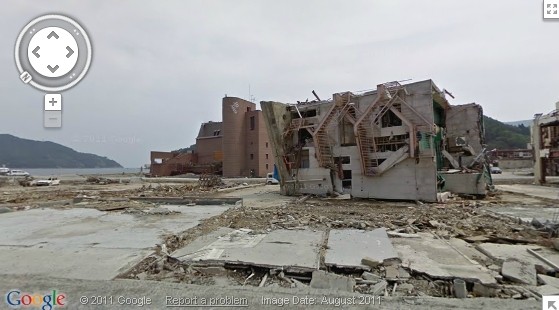
The search giant has also made the imagery available through a special website called Building the Memory where visitors can compare before and after shots of towns forever changed by the disaster.
Google hopes that the images from Japan will ultimately help researchers and scientists to better understand the effects of natural disasters. The images will also help to ensure that the memories of the disaster will remain relevant and tangible for future generations. The team was taking donations for relief efforts through the Google Lat Long Blog earlier this year but Japan likely didn't do itself any favors last week by announcing that $29 million of post-tsunami recovery funds were being allotted to the whaling industry.
https://www.techspot.com/news/46647-google-archives-japan-tsunami-damage-through-street-view.html
 one day I will, one day...