In a nutshell: Much of the world is under lockdown to help slow the spread of Covid-19, but knowing how many people are adhering to the rules can be difficult. That's where Google comes in. The search giant is using Google Maps location data from people who agreed to share their history to show who is staying and working at home.
In its Covid-19 Community Mobility Reports, Google uses anonymized data from users in 131 countries---some regions show state and county---to show their movement trends. "No personally identifiable information will be made available at any point," said the company.
The information covers six categories: Retail and recreation (restaurants, cafes, shopping centers, etc.), Grocery & pharmacy (grocery markets, food warehouses, drug stores, etc.), Parks, (public beaches, marinas, etc.) transit stations, workplaces and residences. Google says the information covers the past several weeks up to until the last 48 to 72 hours.
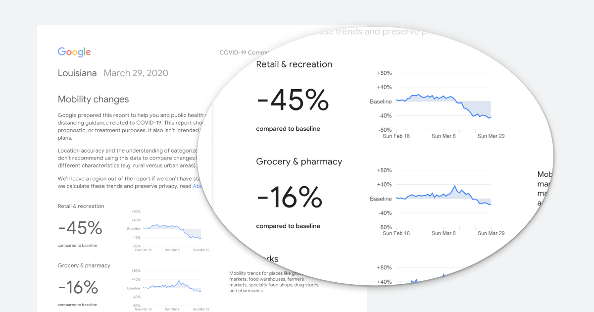
"As global communities respond to the COVID-19 pandemic, there has been an increasing emphasis on public health strategies, like social distancing measures, to slow the rate of transmission," wrote Google Geo SVP Jen Fitzpatrick. "In Google Maps, we use aggregated, anonymized data showing how busy certain types of places are---helping identify when a local business tends to be the most crowded. We have heard from public health officials that this same type of aggregated, anonymized data could be helpful as they make critical decisions to combat COVID-19."
While the reports are designed primarily to help public health officials, anyone can access them by selecting a country and downloading the PDF.
In New York, which has been hit particularly hard by Covid-19, movement to retail and recreation is down 62 percent, while transit station mobility is down 68 percent.
We heard earlier this month that the US government could work with tech firms to track the spread of Covid-19 using phone location data, and it was later revealed that this movement would be tracked using data collected from mobile ads. We've also heard that controversial firm NSO Group is making spyware that tracks and predicts the spread of the virus. Governments from several other countries, including India, Taiwan, and Singapore, are also using location data to monitor novel coronavirus infections.