AI Tech Culture A new map reveals the true scale of America's AI data center boom Researchers are using open-source intelligence, satellite imagery, and local permits to map facilities By Skye Jacobs, January 7, 2026, 10:32 AM
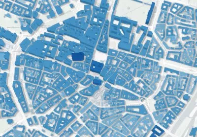
The Web Software Machine learning just helped researchers create the biggest 3D map of buildings around the world Researchers publish GlobalBuildingAtlas, mapping 2.75 billion buildings in 3D By Alfonso Maruccia, December 13, 2025, 11:16 AM
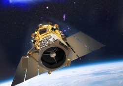
Space Tech Culture BlackSky captures high-quality photos of Earth less than a day after launching its new satellite BlackSky says its new Gen-3 satellite can spot cars, ships – even people and their shadows By Alfonso Maruccia, November 27, 2025, 10:44 AM 7 comments
Google Redesigned Google Earth adds guided tours, 3D view and more By Shawn Knight, April 19, 2017, 7:00 AM
Google The Web Watch our planet endure three decades of change with Google Timelapse By Shawn Knight, November 30, 2016, 6:15 AM
Google The Web Google infuses Earth and Maps apps with super sharp satellite imagery By Shawn Knight, June 28, 2016, 11:30 AM 7 comments
Industry The Web World's first super-spectral, high-resolution commercial satellite launching Wednesday By Himanshu Arora, August 11, 2014, 11:30 AM
Industry Higher-resolution satellite imagery approved by Department of Commerce By Shawn Knight, June 16, 2014, 2:30 PM
Industry Google agrees to buy satellite imagery startup Skybox for $500 million By Shawn Knight, June 10, 2014, 5:45 PM
Industry Google infuses mapping products with cloud-free imagery By Shawn Knight, June 28, 2013, 9:30 AM
Microsoft Bing Maps gets 121 terabytes of new satellite and aerial imagery By Shawn Knight, November 30, 2012, 1:00 PM
The Web Google Maps gets high-res aerial imagery for 72 countries, regions By Rick Burgess, July 30, 2012, 5:00 PM